Coordinate/Antenna
Master Station Settings
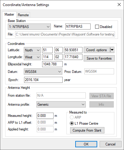
This option allows modification of the master station coordinates, station name and antenna information. Individual base stations can also be disabled from this dialog.
For more information about the Coordinates, Datum, Epoch, Antenna Height and Antenna Profile, see Add Master File(s).
Coord. Options
The following options are available from the Coord. options pull-down menu.
Select From Favourites
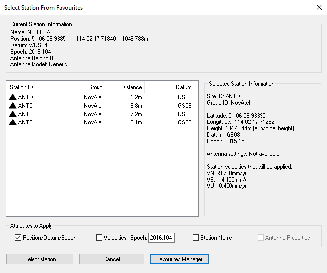
Precise coordinates for CORS, IGN and IGS stations are regularly maintained within the manufacturer files. If downloading base station data from one of these networks, you can load the published coordinates using the Select Station From Favourites button in the master coordinate dialog. This returns a list of the closest stations to the coordinates loaded.
When selecting a station from favourites, be sure to note the available Attributes to Apply at the bottom of this dialog. This provides the ability to copy not only the position and datum information from the favourites, but also the station name, antenna properties (if available) and station velocities. If velocities are selected, the station velocities are applied to the published coordinates and reference epoch to update them to a user-specified epoch. The default epoch is the date of the survey.
Compute from PPP
This feature can be used to compute or check base station coordinates. If used, this feature will check for the presence of precise clock and orbit files required for PPP to deliver accurate results. If no files are present, the best available at the time of download will be downloaded automatically. If a Waypoint TerraStar NRT license has been activated, the Waypoint TerraStar NRT precise products will be downloaded prior to processing the PPP solution. Additionally, if you have a NovAtel receiver with the NRT files, PPP-AR will be used for coordinate determination. The Computing Coordinates Using PPP dialog will then report the processed position at the epoch of the data collected, within the base station coordinate datum chosen. The horizontal and vertical difference between the computed coordinate and the coordinate currently loaded on the master dialog will be reported. A user can then decide to accept the computed coordinates or to select Cancel, if this was only being used as a check.
Use average position
This will load the average position from the GPB file. This position is often only accurate to several meters and is not of sufficient accuracy for the majority of applications.
Enter grid values
This feature launches the Enter grid coordinates dialog, which allows a user to directly enter published grid coordinates, such as UTM and State Plane values. ECEF coordinates can also be entered using this feature.
Enter MSL height
This feature launches the Enter Orthometric (Mean Sea Level) Height dialog. It allows a user to directly enter a published MSL height for a base station. When doing so, an ellipsoidal height must be computed from the MSL height, as all position computations are done relative to the ellipsoid. As such, it is required to point to a geoid in WPG format and the ellipsoidal height will be calculated using the interpolated geoid undulation and the entered MSL height. Please see http://www.novatel.com/support/waypoint-support/waypoint-geoids/ to access all of Waypoint's geoids in WPG format.
Save to Favourites
This option launches the Add to Favourites dialog, which allows a user to save master station coordinates, datum, epoch, and antenna information in order to easily apply that information in future projects that use the same base station.
Remote Settings
This option lets you customize the remote’s antenna information. See Add Remote File for additional information.