Add Remote File
Only one remote file can be added to an Inertial Explorer project. The file must be converted to GPB prior to adding it to the project. When selecting the remote GPB file, Inertial Explorer will automatically check for any associated IMU data (*.imr file), DMI data (*.dmr file), heading data (*.hmr file) and mount data (*.mmr) and prompt you whether you would like to add this data to the project as well.
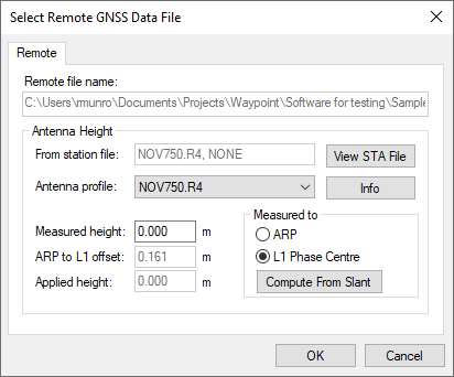
When adding a remote GPB file, ensure the Measured height of the antenna is set to zero. Inertial Explorer uses the entered IMU to GNSS lever arm in order to transfer the GNSS position updates to the IMU center of navigation during processing. A vector can be entered from the IMU to any other sensor or point of interest on the vehicle during Export to transfer position data.
How to add a remote file
-
Select File | Add Remote File.
From the list of available GPB files, choose the file collected at the remote station.
-
When prompted, enter the remote station antenna information.
For GNSS+INS applications (IE or IEX), the Measured Antenna Height should be entered as zero, and the Measured to setting should be L1 Phase Center. In IE or IEX, users are required to enter a lever arm measured from the IMU center of navigation to the GNSS antenna on the main processing dialog. If your lever arm is measured to the ARP, it can be adjusted later in the processing menu.
Compute from Slant
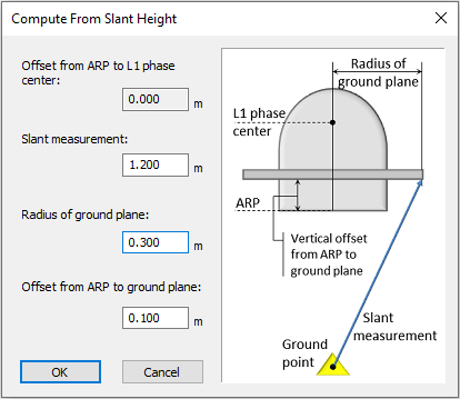
The Compute from Slant feature enables the automatic computation of the true vertical Applied height required by GrafNav and Inertial Explorer given a slant measurement, the radius of the ground plane edge and the offset from the ARP to the ground plane edge.