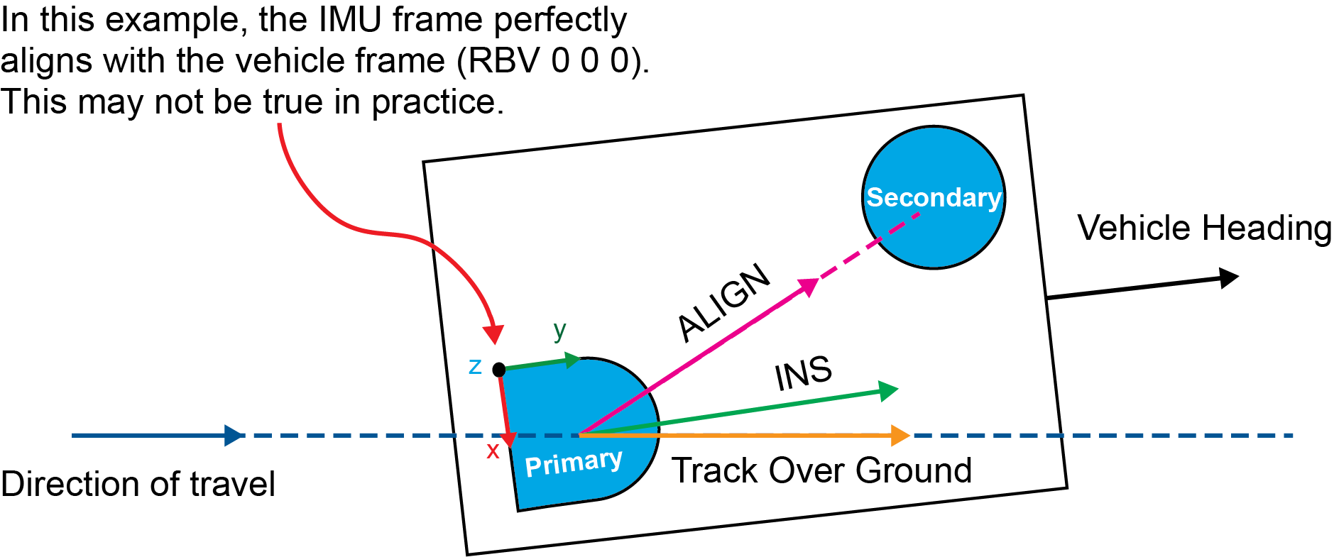
SPAN system definition of azimuth
|
Platform: |
OEM719, OEM729, OEM7500, OEM7600, OEM7700, OEM7720, PwrPak7, CPT7, CPT7700, SMART7-S |
Azimuth is a bearing (the angle between reference frames) defined as a left-handed rotation measured, from 0-360 degrees clockwise, from geographic north to a target direction.
Within the context of the SPAN system, the following azimuths are computed:
-
INS Azimuth – the IMU orientation from the SPAN inertial system.
-
ALIGN Azimuth – the GNSS ALIGN orientation from dual-antenna.
-
Track Over ground Azimuth – the direction of travel.
INS azimuth
The target direction of the INS azimuth is the orientation of the positive y-axis of the INS output frame. The SPAN system computes the attitude of the IMU, which is the orientation of the IMU-frame with respect to the local-level frame, that attitude is rotated to the output frame. By default, the output frame is the vehicle frame as defined by the RBV rotation – if a USER rotation is entered, the output frame defined by the USER rotation offset is used instead (see the SETINSROTATION command).
INS azimuth is available in the logs indicated in Table: Logs with azimuth data.
ALIGN azimuth
The target direction of the ALIGN azimuth is the dual antenna baseline, from the primary antenna to the secondary antenna. The horizontal length of the antenna baseline directly affects the quality of the azimuth solution, a longer baseline results in a more accurate and less noisy ALIGN azimuth. In GNSS documentation and logs, ALIGN azimuth is also referred to as ALIGN heading. See the
ALIGN azimuth is available in the logs indicated in Table: Logs with azimuth data.
Track over ground azimuth
The target direction of the track over ground azimuth is the direction of travel of a point over the surface of the earth. This is computed from position differences or horizontal component of velocity from the selected output solution. Higher velocities result in improved accuracy and reduced noise on the track over ground azimuth, it is undefined when the velocity is zero. In other documentation and logs, track over ground azimuth is also referred to as course over ground or track made good.
Track over ground azimuth is available in the logs indicated in Table: Logs with azimuth data.
Comparison of azimuth sources
Whereas INS azimuth and ALIGN azimuth represent an orientation and are fixed with respect to the vehicle heading (even if they are not aligned), the track over ground azimuth depends solely on the direction of travel of the vehicle.
Depending on the application, implement drag, cross winds, and/or currents can cause the vehicle’s forward axis to not align with the direction of travel. The angular offset between the track over ground and the vehicle heading is the crab angle (or slip angle).
The difference between the three azimuths is illustrated below:
Azimuth comparison