Processing Window

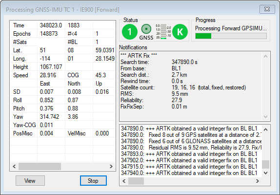
This window appears during processing and shows position, status, progress and any high priority messages output by the processing engine.

Click the View button to customize the fields displayed during processing. See Notifications for descriptions of variables which can be monitored during data processing.

The values in Plot Results differ in the manner in which they are computed depending on the mode of processing being performed.

If the GNSS is being processed, then the values displayed are those computed in the Kalman filter. However, during the IMU processing, the values displayed reflect those calculated in the IMU Kalman filter, using the GNSS information as updates. Ideally, these values should agree. When they do not, monitor the position and velocity misclosure.

The Processing window is updated twice a second.

Status

The Status section of the processing window reports the instantaneous quality number. Quality numbers are meant to provide a high level indication of solution quality and are further described in Table: GNSS Quality Number Description.

If integer carrier phase ambiguities have been fixed, a green circle with the word Fixed will be shown immediately to the right of the quality number. The ARTK statistics of the fix will be shown in the Notifications window below. If integer ambiguities have not been fixed, a blue circle with the word KAR (Kinematic Ambiguity Resolution) will be shown instead.

The instantaneous estimated position error will be shown on a meter immediately to the right of the fixed/float ambiguity status.

Immediately to the right of the estimated position error is the static/kinematic processing mode. If the data is processed in kinematic mode, a green K will be shown, otherwise if the data is processed in static mode a red S will be shown.

Progress

The Progress box graphically displays how much of the data has been processed and how much remains.

View

In the left-hand window, various parameters are available for display via the View button. The list of available parameters is given in Table: Processing Window Parameters.

Notifications

The Notifications window displays all information pertaining to the last ARTK fix. Descriptions of these messages are found in Notifications Windows Messages.

Notifications Windows Messages

Message

Description

Search time

Time at which ARTK engaged.

From base

Specifies which base station ARTK used to fix ambiguities. This will often be the closest base station in multi-base projects.

Search distance

This is the baseline distance when ARTK was first engaged.

Rewind time

When ARTK achieves a fix, the integer carrier phase ambiguities (data quality permitting) can be applied backwards in time to the moment ARTK was engaged. The rewind time reports the number of seconds ARTK was able to restore integer ambiguities backwards from the engage time.

Satellite Count

The number of satellites used by ARTK. The total, fixed and restored numbers are reported.
Total
represents the number used in the float solution.
Fixed indicates the number which achieved fixed integers at the restore time.
Restored indicates the number of satellites where it was possible to restore backwards in time (see Rewind time)

Fix Type

Will either be reported as GNSS Fixed or GNSS Fixed/Verified.

RMS

The RMS of an ARTK fix represents the mathematical fit of the carrier phase measurements. Low RMS values (3 mm or less) represent very good fitting solutions. While this does not guarantee a correct solution, it is a good indication. High RMS values (above 20 mm) may still be correct but the chances of an incorrect fix are higher. Regardless, the Combined Separation with Fixed Ambiguity plot can be accessed to help identify incorrect ambiguity fixes.

Reliability

Reliability is a unitless value that indicates how much better the best ARTK fix is from the second best. This is determined by dividing the RMS of the second best fix by the RMS of the best fix. High reliability values (above 3) indicate a high probability the fix is correct as the best ARTK fix appears much stronger than the second best.

FloatFixSep

This is the distance between the fixed integer solution and the last float solution prior to achieving a fix. Large values (meter level) can be expected where ARTK uses only several seconds of data, as the float solution will not be well converged. Unusually high float/fixed separation values of 5 m or more may be suspect.

FixFixSep

This is the distance between the position computed with a previous set of ambiguities and the position computed with newly accepted fixed ambiguities.

Notifications for Static Processing

Message

Information

RMS

Similar to the RMS computed for an ARTK fix, the RMS of a fixed static solution represents the fit of the carrier phase measurements.

Reliability

See Reliability for ARTK fixes in Table: Notifications Windows Messages for a definition.

The reliability for long fixed static solutions may be reported as N/A, which indicates that only one fix was within the search area. Thus, there was no second best RMS in order to use in computing reliability.

Frequency

Reported as single or dual to indicate whether an L1 only or L1/L2 solution was computed.

Time

The length of time used by the fixed integer solution in hh:mm:ss format.

Type

Fixed static solution type used.

Continuous looks for the best continuous block of cycle slip free data to use within the fixed integer solution.

NewFixed (multi-sat) uses all of the data, although it may reject some sections of data for individual satellites.

Processing Window Parameters

Parameter

Description

Attitude

Displays information such as the Roll, Pitch and Yaw values and standard deviations. Also provides the Yaw-COG separation.

Baseline Data (MB)

Displays the distance, carrier phase RMS and number of satellites for each baseline.

Baseline Distance

Distance separation for projects containing only one base station.

DOPs

Displays DD_DOP, PDOP, HDOP and VDOP.

Estimated Accuracy

The instantaneous north, east and height standard deviation of the remote position.

Geographic Position

Displays the instantaneous position and ellipsoidal height of the remote.

Measurement RMS

The RMS of the code and phase measurements are displayed, together with their standard deviation (measurement weight) in the Kalman filter.

Speed/COG

Speed of the vehicle is displayed with the Course-Over-Ground (COG), computed between consecutive measurement epochs.

Status Flags

Provides the number of satellites and number of baselines.

Time/Epochs

Displays time in seconds of the week, as well as a continuous count of epochs processed. The GPS week number is also shown.

Pos/Vel Misclosures

Provides the misclosures for the position and velocity.

Channel Data B/L

Allows for selection of baseline for which to display channel information.