Moving Baseline Options (GrafNav Only)
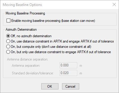
Enable moving baseline processing if your application involves azimuth determination between two antenna on the same vehicle or relative vector determination between two moving antennas on separate moving platforms.
When moving baseline processing is enabled, GrafNav cannot fix the base station position. Every processing epoch uses a different base station position, which is read from the GPB file. The absolute positioning accuracy of each instantaneous base station position is thus limited to the autonomous positioning accuracy of the receiver used. This is generally no better than 2 m horizontal and 5 m vertical.
Although the absolute positioning accuracy in moving base mode is approximate, this is not of interest to most moving base applications. Only the relative position difference and/or azimuth between the antennas is typically required. When ARTK resolves carrier phase ambiguities in moving base mode, the relative positioning accuracy between base and remote is the same as in stationary base mode.
If moving base is enabled, choose from one of the four Azimuth determination options explained below.
Azimuth Determination Options
Off, no azimuth determination
Use this option if both antennas are on separate moving platforms and the azimuth between the antennas is not of interest (i.e. only the relative position and/or velocity).
On, use distance constraint in ARTK and engage ARTK if out of tolerance
Use this option if both antennas are fixed to the same moving platform and a post-processed azimuth is required. This option requires that you input the surveyed distance between GNSS antennas as it is used as a distance constraint in ARTK.
On, but compute only (don't use distance constraint at all)
Use this option if the surveyed distance between the antennas is not known, or is known to change significantly during the survey.
On, but only use distance constraint to engage ARTK if out of tolerance
When this option is used, the distance constraint is not applied when resolving carrier phase ambiguities. Rather, it is used only to re-engage when the computed distance disagrees with the surveyed distance significantly (based on the standard deviation applied to the distance constraint).