General (Differential Settings)
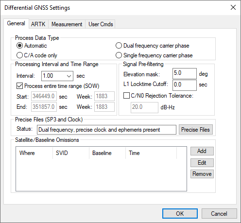
Process Data Type
Defines the type of data used for processing.
Automatic
Chooses between dual frequency, single frequency and C/A only depending on what measurements are in common between the base and remote.
C/A code only
Only C/A code measurements are applied in this method of processing which is limited to meter-level accuracy.
Dual frequency carrier phase
Dual frequency processing should always be used for best results if both base and remote provide dual frequency data. Ambiguity resolution is faster, more reliable and possible at longer baselines lengths than single frequency processing. For long baselines (>7 km by default), ionospheric processing is automatically engaged, helping to preserve post-processed accuracy with increasing baseline length.
Single frequency carrier phase (Differential GNSS processing only)
Single frequency processing uses L1/B1/E1/L1CA measurement only from GPS and GLONASS, BeiDou, Galileo and QZSS if available. While ambiguity resolution can still be successful on short baseline lengths, this method of processing is generally associated with decimeter level applications. As the ionospheric error cannot be directly measured and removed, as in dual frequency processing, post-processed accuracy quickly degrades with increasing baseline length.
Processing Interval and Time Range (SOW)
The data rate of the remote GPB file is used as the default processing interval. However as only common data between the base station and remote can be processed, you will need to ensure the base station(s) were also logged or resampled to the same interval in order to output a trajectory at this interval. Pre-processing checks will output a warning if the master data rate is detected to be less than the remote and will automatically resample the base station data to the remote interval to correct the issue should you select Continue with the Try to fix option engaged on the pre-processing dialog.
By default, all common data between master and remote is processed but a specific time range in GPS seconds of the week can be entered here. The start and end processing times can also be set by right clicking on the Q/C plots.
Signal Pre-filtering
Elevation Mask
Satellites below this elevation (relative to the horizon) are ignored. Common elevation masks for differential kinematic processing are 10-12 degrees. Static processing generally benefits from a higher elevation mask (15 degrees).
Low elevation signals are more affected by multipath and tropospheric error, and are more likely to be affected by cycle slips due to signal blockages and/or signal attenuation by the antenna. Thus, pre-filtering low elevation signals is generally beneficial to post-processed accuracy. Increasing this value too high may cause satellite geometry to become poor which can affect the performance of integer carrier phase determination.
L1 Locktime Cutoff:
This is the number of seconds that continuous carrier phase tracking is required before measurements will be used. Lowering this value will help to maximize GNSS position availability following a total loss of carrier phase lock. However, using low values increases the likelihood of an incorrect ambiguity fix. This is because the quality of carrier phase measurements may be suspect within the first few seconds the receiver achieves carrier phase lock.
C/N0 Rejection Tolerance
Most often, pre-filtering GNSS signals by elevation mask and L1 locktime cutoff is effective. For specialized applications, introducing an alternative or additional pre-filtering method based on the signal to noise ratio may also be effective.
This option is not engaged by default as not every receiver provides a C/N0 value, and different receivers may output this value at different stages of signal processing. Care should be used if applying this option.
Precise Files (SP3 and Clock)
Precise clock and orbit files can be downloaded by accessing the Precise Files button. Adding a precise ephemeris file will help mitigate residual orbital error on long baselines. Precise clock files are not needed in differential processing as this error cancels completely. However, as both files are required should the advanced tropospheric state be engaged or if a Precise Point Positioning (PPP) solution is later computed, both precise files can be added here. Alternately, an NRT correction file can be added instead of the SP3 and clock files.
Satellite/Baseline Omissions
Pre-filtering options will often remove noisy or problematic data prior to the processing stage. During processing, automatic outlier detection routines work to automatically fix errors when large measurement residuals are detected. Failing all of this, if a problematic measurement or satellite can be identified, usually from repeated warnings during processing regarding a specific satellite prior to a Kalman filter reset occurring, the Omit Satellite Info dialog can be accessed to manually enter satellite omissions.
Satellites to Omit
All Satellites
Disables all satellites from being used.
Only specified satellite
Disables individual satellites from individual constellations.
Baselines to Omit
Omit satellite for all baselines
Applies the satellite omission to all baselines in the project.
Only selected baseline
Applies the satellite omission only to the specified baseline (applies to multi-baseline projects only).
Time Period
Omit for entire data set
Applies the omission to the entire processing time range.
Use specified time range
Applies the omission to a specific time period, entered in GPS seconds of the week.