Export to DXF
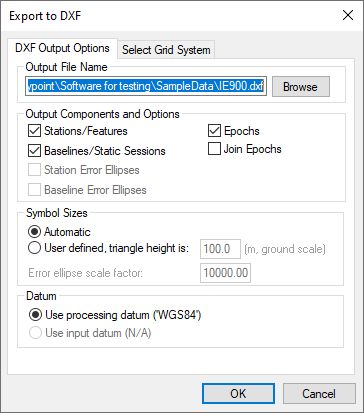
DXF is a file format read by various CAD packages. This utility outputs the contents of the map window to DXF format.
Output File Name
Specify the name and path of the DXF to be created.
Output Components and Options
The following options are available:
Stations/Features
Outputs any stations or features loaded.
Baselines/Static Sessions
Outputs baselines between all the static sessions. The color of the baselines will be the same as it appears in the Waypoint application and is determined by the quality factor.
Epochs
Outputs the trajectory and is only useful for kinematic data. Color is determined by the quality factor.
Join Epochs
Joins a line between epochs.
Symbol Sizes
These settings govern the size of the features and stations in the DXF file. Automatic is suggested for a trial.
Datum
Allows you to choose between the processing datum or the input datum.
The grid options are available under the Select Grid System tab. For UTM, State Plane or any other zone-dependent grid, check that the zone number is correct because the default is likely wrong.