SETNAV
Sets start and destination waypoints
|
Platform: |
OEM719, OEM729, OEM7500, OEM7600, OEM7700, OEM7720, PwrPak7, CPT7, CPT7700, SMART7, SMART2 |
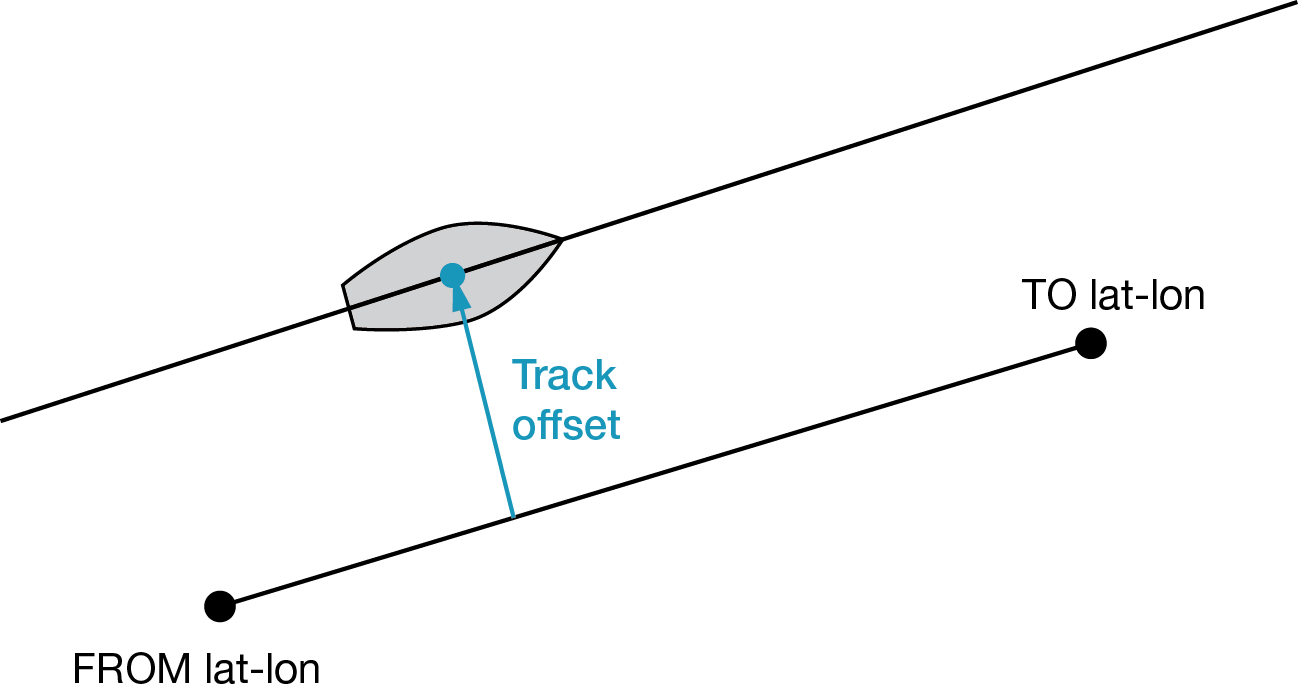
This command permits entry of one set of navigation waypoints (see Figure: Illustration of SETNAV parameters). The origin (from) and destination (to) waypoint coordinates entered are considered on the ellipsoidal surface of the current datum (default wgs84). Once SETNAV has been set, monitor the navigation calculations and progress by observing messages in the NAVIGATE log.
Track offset is the perpendicular distance from the great circle line drawn between the from lat-lon and to lat‑lon waypoints. It establishes the desired navigation path or track, that runs parallel to the great circle line, which now becomes the offset track, and is set by entering the track offset value in metres. A negative track offset value indicates that the offset track is to the left of the great circle line track. A positive track offset value (no sign required) indicates the offset track is to the right of the great circle line track (looking from origin to destination). See Figure: Illustration of SETNAV parameters for clarification.
Message ID: 162
Abbreviated ASCII syntax:
SETNAV fromlat fromlon tolat tolon trackoffset from-point to-point
Factory default:
SETNAV 90.0 0.0 90.0 0.0 0.0 from to
ASCII example:
SETNAV 51.1516 -114.16263 51.16263 -114.1516 -125.23 FROM TO
Consider the case of setting waypoints in a deformation survey along a dam. The surveyor enters the From and To point locations, on either side of the dam using the SETNAV command. They then use the NAVIGATE log messages to record progress and show where they are in relation to the From and To points.
|
Field |
Field type |
ASCII value |
Binary value |
Description |
Format |
Binary bytes |
Binary offset |
|
1 |
Command header |
- |
- |
SETNAV header This field contains the command name for abbreviated ASCII or the message header for ASCII or Binary. |
- |
H |
0 |
|
2 |
fromlat |
± 90 degrees |
Origin latitude in units of degrees/decimal degrees. |
Double |
8 |
H |
|
|
3 |
fromlon |
± 180 degrees |
Origin longitude in units of degrees/decimal degrees. |
Double |
8 |
H+8 |
|
|
4 |
tolat |
± 90 degrees |
Destination latitude in units of degrees/decimal degrees |
Double |
8 |
H+16 |
|
|
5 |
tolon |
± 180 degrees |
Destination longitude in units of degrees/decimal degrees |
Double |
8 |
H+24 |
|
|
6 |
trackoffset |
± 1000 km |
Waypoint great circle line offset (in metres) establishes offset track. Positive indicates right of great circle line and negative indicates left of great circle line |
Double |
8 |
H+32 |
|
|
7 |
from-point |
5 characters maximum |
ASCII origin station name |
String [max 5] |
Variable1 |
H+40 |
|
|
8 |
to-point |
5 characters maximum |
ASCII destination station name |
String [max 5] |
Variable1 |
Variable |
|