MAGVAR
Sets a magnetic variation correction
|
Platform: |
OEM719, OEM729, OEM7500, OEM7600, OEM7700, OEM7720, PwrPak7, CPT7, CPT7700, SMART7, SMART2 |
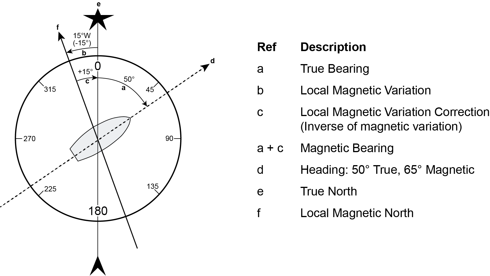
The receiver computes directions referenced to True North (also known as geodetic north). The Magnetic Variation Correction command (MAGVAR) is used to navigate in agreement with magnetic compass bearings. The correction value entered here causes the "bearing" field of the navigate log to report bearing in degrees Magnetic. The receiver computes the magnetic variation correction when using the auto option. See Figure: Illustration of magnetic variation and correction.
The receiver calculates values of magnetic variation for given values of latitude, longitude and time using the International Geomagnetic Reference Field (IGRF) 2020 spherical harmonic coefficients and IGRF time corrections to the harmonic coefficients. (IGRF-2020 is also referred to as IGRF-13.) The model is intended for use up to the year 2025. Furthermore, the receiver will compute for years beyond 2025, but accuracy may be further reduced depending on the behaviour of the magnetic pole.
Message ID: 180
Abbreviated ASCII syntax:
MAGVAR type [correction [std dev]]
Factory default:
MAGVAR correction 0 0
ASCII example 1:
MAGVAR AUTO
ASCII example 2:
MAGVAR CORRECTION 15 0
Magnetic North refers to the location of the Earth's Magnetic North Pole. Its position is constantly changing in various cycles over centuries, years and days. These rates of change vary and are not well understood. However, we are able to monitor the changes.
True North refers to the earth's spin axis, that is, at 90° north latitude or the location where the lines of longitude converge. The position of the spin axis does not vary with respect to the Earth.
The locations of these two poles do not coincide. Thus, a relationship is required between these two values for users to relate GNSS bearings to their compass bearings. This value is called the magnetic variation correction or declination.
GNSS does not determine where Magnetic North is nor do the satellites provide magnetic correction or declination values. However, OEM7 receivers store this information internally in look up tables so that when you specify that you want to navigate with respect to Magnetic North, this internal information is used. These values are also available from various information sources such as the United States Geological Survey (USGS). The USGS produces maps and has software which enables the determination of these correction values. By identifying your location (latitude and longitude), you can obtain the correction value. Refer to An Introduction to GNSS available on our website at novatel.com/an-introduction-to-gnss.
|
Field |
Field type |
ASCII value |
Binary value |
Description |
Format |
Binary bytes |
Binary offset |
|
1 |
Command header |
- |
- |
MAGVAR header This field contains the command name for abbreviated ASCII or the message header for ASCII or Binary. |
- |
H |
0 |
|
2 |
type |
AUTO |
0 |
Use IGRF corrections |
Enum |
4 |
H |
|
CORRECTION |
1 |
Use the correction supplied |
|||||
|
3 |
correction |
± 180.0 degrees |
Magnitude of correction (Required field if type = Correction) |
Float |
4 |
H+4 |
|
|
4 |
std_dev |
± 180.0 degrees |
Standard deviation of correction (default = 0) |
Float |
4 |
H+8 |
|